Page Maison
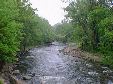
La rivičre Chateauguay prends sa source au Lac Chateaugay dans l'état de N.Y. (Brainerdsville) pour se vider dans le Lac St-Louis ŕ Chateauguay Qué. Cette photo fut prise de la vieille scirie regardant vers le nord a Powerscourt. (Huntingdon). La rivičre a de belles brunes et arc-en-ciels qui sont ensemencées ŕ tous les ans. L'accčs ŕ la rivičre peut se faire par le Pont Percy ŕ Powerscourt oů tout le long de la rivičre. Il y a plusieurs places pour le stationnement qui est fournis par le Dept. de l'Environnement et de la Faune du Québec. Vous pouvez pęcher vers l'amont qui vous ammenera vers les frontičres des Etats Unis. Veuillez respecter les terrains privés.
Comment s'y rendre: Prendre la route 132 jusqu'ŕ Huntingdon et au milieu du village emprunté le pont vers la gauche. Au premier arręt, tournez vers la droite et suivez la rivičre pour environ 12 km. Il y a accčs ŕ la rivičre tout le long du parcours.
Passez une bonne journée de pęche et arrętés ŕ la boutique pour nous laisser savoir si vous avez fait bonne pęche.
Le Moucheux
Home Page
The Chateauguay River takes its source at the Chateauguay Lake in Brainersville N.Y. to empty in Lake St-Louis, Chateauguay, Quebec. This picture was taken in Powerscourt (Huntingdon)from the old mill looking south. It holds nice browns and rainbows. Access can be found
at the old Percy covered bridge and all along the the river.
There is lots of parking supplied by the Quebec Fish and Game Dept.
Please respect land owners and private properties. You can fish
up river for about 1 mile before you end up at the American border.
How to get there: Take route 132 to Huntingdon and turn left at
the bridge in the center of town. At the first stop sign, turn
right and drive for about 12 kms. following the river on your right.
You cant miss it. Have a nice fishing day, and stop
by the shop to let me know how the fish were biting.
Le Moucheux.
